Spar
Imray Chart G32
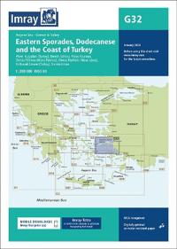
Plans included: Kusadasi (Turkey) (1:17 500) Stenón Sámou (1:85 000) Póros Fóurnon (1:25 000) Órmos Pátmou (Nísos Pátmos) (1:50 000) Órmos Parthéni (Nísos Léros) (1:50 000) Yalikavak Limani (Turkey) (1:75 000) Stenón Lérou (1:50 000) Imray-Tetra charts for the Ionian and Aegean are widely acknowledged as the best available for the cruising sailor. They combine the latest official survey data with first-hand information gathered by Rod and Lucinda Heikell. The chart is designed to be used alongside Imray pilot guides of the area. Like all Imray charts, they are printed on water resistant Pretex paper for durability, and they include many anchorages, facilities and inlets not included on official charts.
- Undertittel
- Eastern Sporades, Dodecanese & the Coast of Turkey
- ISBN
- 9781786795533
- Vekt
- 67 gram
- Serie
- G Charts
- Utgivelsesdato
- 4.1.2024
- Antall sider
- 1
