Sökt på: karta
totalt 7 036 träffar

Southern England
This map, covering Southern England, extends to Gloucester and Swindon in the west, Peterborough and Leicester in the north, to the coast in the east and south. Included is a large …

Liverpool (Vauxhall) 1864
Liverpool Large Scale. .

Wander-, Ski- und Radwanderkarte Oberhof, Ilmenau, Zella-Mehlis und Umgebung
Mit Straßennamen zur besseren Orientierung, farbig hervorgehobenen Ausflugszielen, Sehenswürdigkeiten der Umgebung in Text und Bild und alle regionalen und überregionalen Wander- …

Laminated Y49 Isles of Scilly (Small Format)
Plan included St Mary's Road (1:25 000) Part of the small format Y series (A2 size), this replicates sheet 2400.3 from the 2400 West Country Chart Pack

Southend-On-Sea & Basildon
OS Explorer is the Ordnance Survey's most detailed map and is recommended for anyone enjoying outdoor activities like walking, horse riding and off-road cycling. The OS Explorer …

Ste-Eulalie-d'Olt / Hte Vallée du Lot / Mt d'Aubrac

Britain Pocket Map

John Hancox's Map of the Birmingham Canal Navigations 1864
Detailed and fascinating survey map of the Birminghams Canal Navigations re-worked from the rare Hancox original dated 1864. The map folds out to a large 1000mm x 890mm size that …

Rand McNally Folded Map: New Orleans Street Map

Aberystwyth and Cwm Rheidol

Nuuksio Noux -retkeilykartta 1:15 000
Nuuksion järviylänkö koostuu kansallispuistosta ja useista kaupunkien ulkoilualueista retki- ja luontopolkuineen. Mosaiikkimaisessa maastossa vuorottelevat kallioiset metsämaat ja …
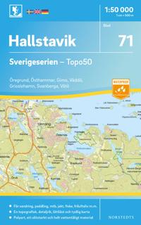
71 Hallstavik Sverigeserien Topo50 : Skala 1:50 000
Sverigeseriens friluftskartor är en serie om 116 kartor med ett täckningsområde som sträcker sig över södra och mellersta Sverige samt Norrlandskusten. Det är kartan för dig som …