karta, falsad., 2024, Engelska, ISBN 9780008653118
Explore the whole county and area extending into Devon as far as Great Torrington, Tavistock and Plymouth. This detailed and up-to-date map contains more than 1,000 places of …
karta, falsad., 2022, Engelska, ISBN 9780008520694
Explore new places with handy pocket maps from Collins. Handy little full colour map of the Cotswolds. Detailed mapping and tourist information ideal for any …
karta, falsad., 2023, Engelska, ISBN 9780008604417
Explore the whole region of Yorkshire extending from Sheffield to Darlington. With detailed road mapping and illustrated town plans of major cities, this feature rich, helpful …
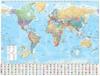
Delight in the world’s most authoritative atlas – a unique and timeless gift for all occasions. Now in its 16th edition, the world’s most authoritative atlas has been …
karta, falsad., 2022, Engelska, ISBN 9780008492618
Från 86 kr
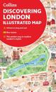
A new edition of London’s most original map. This hand-watercoloured map contains individual paintings of all the main sites and landmarks, shop-by-shop street maps, theatres and …
karta, falsad., 2023, Engelska, ISBN 9780008580001
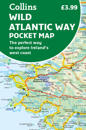
Explore new places with handy pocket maps from Collins. Handy full-colour map of Ireland’s Wild Atlantic Way with a high level of detail. Clear mapping of the full 2500 …
karta, falsad., 2023, Engelska, ISBN 9780008607104
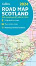
Full-colour map of Scotland at 8.7 miles to 1 inch, with clear road network and administrative areas shown in colour. The map covers the whole of Scotland and part of Northern …
karta, falsad., 2023, Engelska, ISBN 9780008604424
Explore the whole of Scotland from Dumfries and Galloway in the South to the Orkney Islands in the North. With detailed road mapping and illustrated town plans of major cities, …