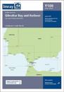
karta, falsad., 2020, Engelska, ISBN 9781786791955
A brand new chart for 2020 covering Gibraltar BayHarbour. This chart is a replica of the Gibraltar sheet found in the Imray chart atlas 3210 Gibraltar to Cabo de la Nao. It is …
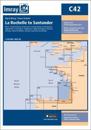
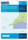
karta, falsad., 2021, Engelska, ISBN 9781786792662
This edition includes the latest official UKHO data combined with additional information sourced from Imray's network to make it ideal for small craft. It includes the latest …
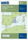
karta, falsad., 2019, Engelska, ISBN 9781786791313
Plans included:Baie de Lampaul (Ouessant) (1:30 000)Port du Conquet (1:20 000)Port de BrestMarina du Moulin Blanc (1:30 000)Marina du Moulin Blanc (1:9000)L'Elorn - Continuation to …
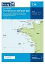
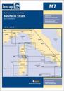
karta, falsad., 2016, Engelska, ISBN 9781846238635
Plans included: La Maddalena (1:10 000) On this 2016 edition the latest depth surveys have been applied where available. The latest nature reserve information is included and the …
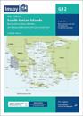
Imray-Tetra charts for the Ionian and Aegean are widely acknowledged as the best available for the cruising sailor. They combine the latest official survey data with first-hand …
Plans included: Puerto de San Antonio (Ibiza) (1:17 500) Puerto de Ibiza (Ibiza) (1:15 000) Puerto de Palma (Mallorca) (1:17 500) Porto Colom (Mallorca) (1:10 000) Puerto de Mahon …