karta, falsad., 2017, Engelska, ISBN 9783707910612
freytagberndt maps are available for many countries and regions in the world. In addition to the precise cartography each map also includes a lot of additional information about …
EasyMap är detaljerade och praktiska kartor över länder och regioner att ta med på resan. Teckenförklaring på svenska och engelska samt ett index med ortnamn.
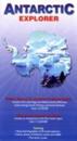
karta, falsad., 2009, Engelska, ISBN 9780954371760
A foldout map of Antarctica continent that shows succinct biographies of Antarctic explorers from William Spiers Bruce to Edward Wilson. It is suitable for visitors arriving by …
karta, falsad., 2007, Engelska, ISBN 9780954371746
Part of the "Ocean Explorer" series, this work covers the Falkland Islands region. It provides a detailed map of the islands with key areas identified. It presents information of …
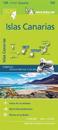
karta, falsad., 2017, Engelska, ISBN 9782067217959
Michelin's Zoom collection are characterized by the high precision of their detailed scale, specially adapted for very touristy areas or with a high density road network, including …
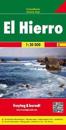
karta, falsad., 2015, Engelska, ISBN 9783707912883
freytagberndt maps are available for many countries and regions in the world. In addition to the precise cartography each map also includes a lot of additional information about …
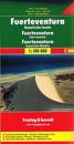
karta, falsad., 2018, Engelska, ISBN 9783850843102
This detailed recto/verso road map of Fuerteventura is very suitable for planning and traveling around the country. The road network is well represented, both the main roads, …