Søkt på: kart, falset
totalt 7 634 treff

Tour du Mont Blanc
The white dome of Mont Blanc looms over France, Italy and Switzerland, and it is no wonder that the 169-kilometre Tour du Mont Blanc (TMB) has captured the public imagination to …

Northern Italy, road map 1:500,000, freytagberndt
The road map north of Italy at a scale of 1:500,000 contains a lot of information that is useful and helpful for a trip to the north of Italy. The branched road network is shown …

Europe Marco Polo Map
Marco Polo Europe Map: the ideal map for your trip Let the Marco Polo Europe Map guide you around this incredible continent. Plan your European road trip with this highly durable …

Iceland
AdventureMaps provide global travellers with the perfect combination of detail and perspective. Iceland's western half is shown on the front side of the map including the cities of …

Mongolia

Lofoten, Vesterålen og Senja 2024
Kartet viser sentrale deler av Troms og Nordland med de nye Nasjonale Turistvegene sammenhengende. Med sentrumskart over Bodø, Narvik, Harstad og Tromsø. I tillegg til dette har …

C80 British Isles
On this edition the magnetic variation curves have been updated with 2020 data. Under new royalty terms, the DGA (Danish Geodata Agency) have made it unviable to reproduce their …

C18 Western Approaches to the English ChannelBay of Biscay
For this 2021 edition the chart has been fully updated throughout using the latest known depths, buoyage, and areas and limits.

Alps (A, Ch, F, I, Slo) Road Map 1:500 000
- City maps- Pass-roads- Index with postal codes
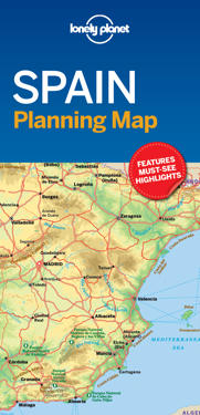
Lonely Planet Spain Planning Map
From Lonely Planet, the world’s leading travel guide publisher Durable and waterproof, with a handy slipcase and easy-fold format, Lonely Planet’s Spain Planning Map helps you get …

Caucasus - Georgia - Armenia - Azerbaijan Road Map 1:700 000
freytagberndt maps are available for many countries and regions in the world. In addition to the precise cartography each map also includes a lot of additional information about …

Stor-Oslo
Stort kart som gir oversikt over hele Oslo-gryta, med Oslos bydelsgrenser, store utbyggingsområder, alle veinavn og de nye bomringene. På baksiden er et eget kollektivtrafikk-kart …