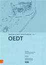
Die Nr. 104 des Rheinischen Stadteatlas ist dem Ort Oedt gewidmet. Das 1170 erstmals erwahnte Oedt gehorte zunachst zur Abtei Monchengladbach. Die bei Oedt liegende Burgruine Uda …
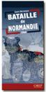
A superb map of the progress of the front line in Normandy from the initial landings in June 1944 through to August 24, 1944. The locations and movements of all the allied units …
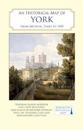
A full colour map based on a digitising of a large-scale map of York surveyed in 1850. The map shows the main medieval and post-medieval buildings in this attractive and …
Michelin's Road to liberty Map 105 covers the region associated with France's liberation between June 1944 and January 1945, at a scale of 1:500,000. This is a reprint of the 1947 …
With maps of Jerusalem & Tel Aviv-Yafo. Cities, towns, villages Built up areas Physical features Archaeological and historical sites Road classifications & numbers Road No. 6 (Toll …