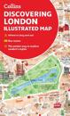
A new edition of London’s most original map. This hand-watercoloured map contains individual paintings of all the main sites and landmarks, shop-by-shop street maps, theatres and …
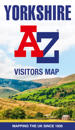
Explore the whole region of Yorkshire extending from Sheffield to Darlington. With detailed road mapping and illustrated town plans of major cities, this feature rich, helpful …
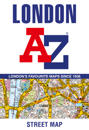
This great value, fold-out map uses our instantly recognisable A-Z street mapping and has handy a TfL Tube map on the back for easy access. Published at a scale of 3.5 …
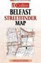
Main map scale 4 inches to 1 mile. Enlarged central area 5.25 inches to 1 mile.Clear detailed street level mapping with full index to street names plus route planning map showing …
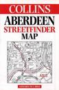
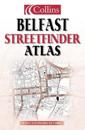
This streetfinder atlas has a scale of 4.25 inches to 1 mile. Fully updated, with clear, easy to use red and black street level mapping, it is fully indexed. An extensive area of …
Navigate your way around Portsmouth with this detailed and easy-to-use A-Z Street Atlas. Printed in full-colour, paperback format, this atlas contains 54 pages of …
This London street atlas covers the area from Heathrow Airport in the west to Barking Creek in the east and from Chigwell in the north to Bromley in the south. It includes …