Filter
- Harpercollins publishers (80)
- Lind co (2)
- Quarto publishing plc (10)
- Crossway books (1)
- Penguin books ltd (38)
- Gaudeamus (2)
- Dorling kindersley ltd (15)
- Antiikki-kirja (1)
- Yale university press (20)
- John nurmisen säätiö (2)
- Scribner book company (3)
- Workman publishing (2)
- Atlasart (4)
- Michelin editions des voyages (1)
- Tuttle publishing (2)
- National geographic society (3)
- Dk (4)
- Dk publishing (dorling kindersley) (2)
- Brief history of asia series (1)
- Dk history map by map (4)
- Atlases of the imagination (2)
- Skrifter utgivna av svenska litteratursällskapet i finland (1)
- In minutes (1)
- Pelican books (1)
- Cambridge library collection - polar exploration (117)
- Cambridge studies in historical geography (38)
- Cambridge library collection - maritime exploration (27)
- Cambridge library collection - hakluyt first series (26)
- Geographers (19)
- Rheinischer städteatlas (21)
- Routledge revivals (13)
- Cambridge library collection - travel, middle east and asia minor (13)
- Cambridge library collection - african studies (14)
- Historical geography and geosciences (9)
- Series in ecology and history (7)
- Environmental history and the american south (7)
Historisk geografi
Filter
-
-

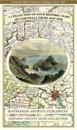
Cornwall 1611 – 1836 – Fold Up Map that features a collection of Four Historic Maps, John Speed’s County Map 1611, Johan Blaeu’s County Map of 1648, Thomas Moules County Map of 1836 and Robert Dawson’s Reform Act Plan of Truro 1831. The maps are surrounded by Cornwall’s Historic Buildings.
av Mapseeker Publishing Ltd.