Hakutulokset: between worlds
Etsimme kuitenkin kirjoja hakusanalla between worlds , mikä antoiyhteensä 23 hakutulosta

World Executive, Poster Size, Tubed
The most up-to-date executive world map from the cartographers at National Geographic, in a smaller poster size. This map features the Winkel Tripel projection to reduce distortion …

World Political Marco Polo Wall Map
Good quality large wall map; ideal for a classroom, bedroom or office wall Explore the world with this high quality, large, laminated, rolled map of the World. The Marco Polo World …

Collins Children’s World Wall Map
Beautifully illustrated wall map for inquisitive kids Colourful Illustrated Map of the World This bestselling, highly illustrated pictorial map is designed to …

The World - Michelin rolled & tubed wall map Paper
Educational and decorative, this World wall map is ideal for use in both home and office. Updated annually and beautifully coloured, this wall map highlights the flags for each …
World Classic, Poster Size, Tubed
The National Geographic Classic World Map is the perfect addition to any home, business or school. This smaller poster-size map (91 x 61 cm) features the entire world, laid out in …

World Executive, Enlarged &, Tubed
The most up-to-date executive world map from the cartographers at National Geographic, in an enlarged size. This map features the Winkel Tripel projection to reduce distortion of …

World political laminated
Laminerad världskarta med politisk indelning. Engelsk text. Format: 103 x 73 cm.

World children's map wall map laminated

Scratch the World mi
Raaputa esiin esimerkiksi maat, joissa olet vieraillut.Raaputuksen alta paljastuu tyylikäs ja ajantasainen maailmankartta.

Scratch the World black edition wall map

Outer Space Glow in the Dark Children's World Wall Map
Kids world wall map which comes to life and will illuminate at night. Playful illustrations of various space objects such as a space rocket, satellites, an astronaut, comets and …

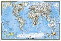
World Classic, Tubed
The most up-to-date political world map from the cartographers at National Geographic. This map features the Winkel Tripel projection to reduce distortion of land masses as they …