This chart is a replica of Imray chart 2200.11 covering Southampton Water. This edition includes the latest official UKHO data, combined with additional information sourced from …
This chart has been reschemed to provide coverage of Portsmouth Harbour and its approaches at a better scale. The product now consists of a package of two charts, replicas of Imray …
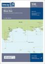
This edition includes the latest official UKHO data, combined with additional information sourced from Imray''s network to make it ideal for small craft. The chart has been fully …
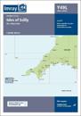
This edition includes the latest official UKHO data, combined with additional information sourced from Imray''s network to make it ideal for small craft. The chart has been fully …
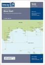
This edition includes the latest official UKHO data, combined with additional information sourced from Imray''s network to make it ideal for small craft. The chart has been fully …
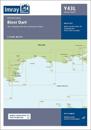
This chart is a replica of Imray chart 2200.2 covering the Western Approaches to the Solent. It is printed on water resistant paper. This edition includes the latest official UKHO …