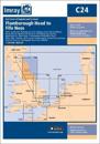
Plans included: Eyemouth Harbour (1:7500) Berwick Harbour (1:12 500) Holy Island Hbr (1:17 500) Farne Islands (1:90 000) Warkworth Harbour (Amble) & Approaches (1:22 500) Blyth …
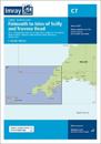
Chart scale 1:120 000 Plans included: Newquay Bay (1:10 000) Saint Ives (1:15 000) St Mary's Road (1:25 000) Hugh Town (1:10 000) Mousehole (1:5000) Newlyn Harbour (1:12 000) …
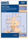
On this 2016 edition the latest depth surveys have been applied throughout. The chart specification has now been improved to show coloured light flashes.
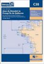
Plans included: Port la Foret (1:15 000) Concarneau (1:15 000) Port Manec'h (1:35 000) Ports BrigneauMerrien (1:20 000) Doelan (1:15 000) Iles de Glenan North (1:30 000) Lorient …