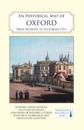
karta, falsad., 2021, Engelska, ISBN 9780993469893
A full colour map, based on a digitised map of the city of Oxford in 1876, with its medieval past overlain and important buildings picked out. The map's cover has a short …
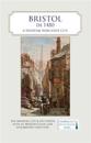
karta, falsad., 2021, Engelska, ISBN 9780993469879
A full colour map, where the city in about 1480 is shown against a background of a detailed Ordnance Survey of the early 20th century. Produced in association with the University …
karta, falsad., 2019, Engelska, ISBN 9781849345170
A brand new clan map of Scotland with over 150 clans from Waverley Books. And on the back, illustrated in colour: Sir Walter Scott's role in the tartan revival; clan badges, …
karta, falsad., 2023, Engelska, ISBN 9781838071950
A full colour map, based on a digitised OS map of Cambridge published in 1927, with its medieval, Georgian, Victorian and Edwardian past overlain and important buildings picked …
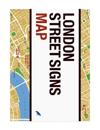
karta, falsad., 2022, Engelska, ISBN 9781912018864
London's street signs reflect centuries of history through their letters, whether carved in stone, enamelled or tiled. These unassuming signs serve as rich visual markers of the …
karta, falsad., 2023, Engelska, ISBN 9780008603014
Discover Scotland with this authoritative guide to clans, tartans, and their origins. These popular maps are highly detailed, showing hundreds of arms, official insignia, …
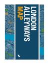
karta, falsad., 2022, Engelska, ISBN 9781912018871
Alleyways have a habit of leading to unexpected places. They act as the city's library: echoing the routes of trade, lost rivers, burial roads, disputed boundaries, tracks of …