karta, falsad., 1990, Engelska, ISBN 9780333480311
A large-scale, easy-to-read map of Mauritius. There are colour photographs accompanied by descriptive text. Other special features included in this series of maps are detailed …
karta, falsad., 2017, Engelska, ISBN 9783707914139
freytagberndt maps are available for many countries and regions in the world. In addition to the precise cartography each map also includes a lot of additional information about …
karta, falsad., 2022, Engelska, ISBN 9781876410810
A detailed fold-out map of the 868 km (539 miles) long archipelago showing the atolls, location of the resorts, as well as the other features, such as protected marine areas, …
karta, falsad., 2023, Engelska, ISBN 9782067259102
(Edition updated in 2023), MICHELIN National Map Maurice (Mauritius) will give you an overall picture of your journey in (Mauritius) thanks to its clear and accurate mapping scale …
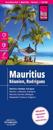
Highly tear-resistant and 100% waterproof map "Mauritius, Reunion, Rodrigues" from the series world mapping project, published by Reise Know-How Verlag.